
御殿山
Goten’yama (palace hill)

Today, we’re breaking from the usual etymology and location breakdown because I’ve already covered this area. I’m sticking to the recent theme of cherry blossoms, but I’d like to try something a little different. Bear with me. But I think you’re all going to like this. There’s an accompanying video at the bottom in which I’ll walk you around all these places.
御殿山 Goten’yama was one of the most popular 花見 hanami cherry blossom viewing spots in 江戸 Edo. It was a bluff in 品川 Shinagawa that sat on the coast of 江戸湾 Edo-wan Edo Bay. It was outside of the city limits of the shōgun’s capital, located in 武蔵国荏原郡 Musashi no Kuni, Ebara-gun Ebara District, Musashi Province near the 二里塚 niri-zuka, a milestone indicating this area was roughly 4.88 miles (7.854 km) from 日本橋 Nihonbashi on the 東海道 Tōkaidō, the highway connecting the shōgunal capital of Edo with the imperial capital of 京都 Kyōto. It was one of the most celebrated spots for hanami, and might still be today, had the shōgunate not destroyed the mountain in 1853 to dump the dirt into the bay for the urgent construction of the 品川台場 Shinagawa Daiba Shinagawa Batteries.

I’ve written about Goten’yama, the Shinagawa Daiba, and to a certain degree Shinagawa. But, I decided to expand on the topic a little bit. I thought it might be nice to compare the area then and now because it’s changed so much – and I’m not just talking about them literally tearing down the mountain. If we transported an Edoite to our time, they’d recognize the layout of the streets, but would be shocked by the destruction of the coastline by landfill and development. They might also find it funny what bits and pieces still exist today and how they’ve been incorporated into our modern lives.
Long time readers should be familiar with most of these topics, but for noobs or anyone wanting to brush up, it’s highly recommended you check out these past articles:
- What does Goten’yama mean?
- What does Odaiba mean?
- What do Shinagawa and Takanawa mean?
- Go-kaidō –Five Great Highways of Edo
- Nagano’s Kiso Valley has preserved post towns similar to Old Shinagawa

Let’s Look at Goten’yama
Hopefully the video walk-through of Goten’yama and its immediate environs will give you an idea of what the place looks like and feels like on the street level. It’s one thing to look at a flat 2D map, it’s another to actually explore the space first hand – everything feels different. Hopefully the video will give you a better sense of this small, but important section of 品川宿 Shinagawa-shuku Shinagawa Post Town, nicknamed 江戸の玄関 Edo no Genkan Edo’s Doorstep[i].
And so, I present you with a map of Shinagawa and Goten’yama in the late Edo Period, but before the government made any major changes to the area in the 幕末 Bakumatsu last days of the Tokugawa Shōgunate (1853-1868).

Fishermen, Travelers, Merchants, Sightseers, Oiran, and Samurai
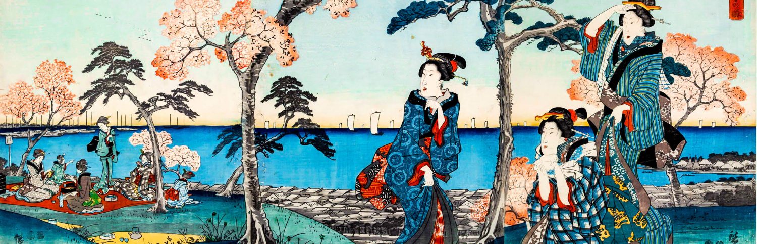
Being a safe location on a bay with calm waters rich with seafood and so busy with land based travelers coming and going every day, Shinagawa turned into a town focused on customer service. Travelers needed lodging and places to eat. They needed places to bathe and purchase goods. Fresh fish and a view of the greatest seaside view an Edo Period person could possibly see were more than enough to make Shinagawa an attractive place to spend not only one, but two days. One of the main attractions was prostitution, big business in any post town[ii]. The difference was, Shinagawa offered access to Goten’yama which gave you access to a commanding, aerial view of the bay. During the day, you could see fishing boats on the water, in the evening, you could see pleasure boats – and just imagine the hijinks that went down on those private voyages[iii].

Many of the 茶屋 chaya teahouses (read: brothels) here became quite famous. One place in particular, the 土蔵相模 Dozō Sagami, remained in operation up until the ban on prostitution by the American Occupation. After that, it operated as a hotel well into the 1950’s. Dozō Sagami had a reputation as a quite high class brothel and was popular among the samurai class. Many anti-shōgunate terrorists frequented this teahouse during the Bakumatsu. The most infamous of these anti-government agitators was a group 17 samurai from 水戸藩 Mito Han Mito Domain and one from 薩摩藩 Satsuma Han Satsuma Domain who held an all-day party here eating, drinking, and banging “tea girls” as if it was their last day on earth.

And, indeed, it was their last day on earth. The next day, resolved to achieve their goal or die trying, they ambushed the shōgunal regent 井伊直弼 Ii Naosuke as he and his entourage left his 上屋敷 kami-yashiki upper residence to attend a meeting next door in 江戸城 Edo-jō Edo Castle. This brazen assassination of the highest ranking shōgunate official in broad daylight was the first of many instances of terrorism that would plague the shōgunate as well as foreign diplomats and merchants in what would become the end of the Pax Tokugawa.
Shinagawa-shuku wasn’t just blessed by the calm waters of Edo Bay, the old post town was protected by a promontory, originally a sandbar created by the estuary of the 目黒川 Meguro-gawa Meguro River that flowed into the bay. That finger-shaped jetty protected the mainland from the occasional irregular high tide or, presumably, tsunami[iv]. Whether it actually prevented catastrophes or not, I don’t know. However, this natural land mass was built up by the shōgunate and came to be known as 洲崎 Susaki which literally means “sandbar promontory,” and it was a permanent fixture of Shinagawa-shuku and you can clearly see it in many famous 浮世絵 ukiyo-e wood block prints. Families of certain fishermen here produced 御菜肴 o-saisakana snacks made from seafood and veggies that were presented to Edo Castle in exchange for their piscatory monopoly in the area.

In 1798, during the reign of 徳川家斉 Tokugawa Ienari[v], a whale washed ashore onto this promontory. This seems to have been a pretty unusual occurrence[vi], and it attracted a lot of local attention. In an age without TV, the word on the street finally made it to Edo Castle itself. Everyone one wanted to come see this huge sea creature that died on the banks of Susaki. It was such a big deal that the shōgun himself even came down to see what was up with this big ass dead fish on his doorstep[vii]. To this day, Shinagawa uses whales in various places as a decorative theme.

A notable feature of the promontory was 洲崎弁天 Susaki Benten a temple dedicated to 弁才天 Benzaiten, the only female deity in the 七福神 Shichi Fukujin 7 Gods of Good Luck. After the 神仏判然令 Shinbutsu Hanzen-rei Edict Separating Shintō and Buddhism in 1868, the temple chose to retain its Shintō attributes and came to be known as 利田神社 Kagata Jinja Kagata Shrine, the name it retains to this day[viii].

On the grounds of the shrine, you can find a monument called the 鯨塚 Kujira-zuka Whale Mound. This was a grave built in memory of the beached whale that died on Susaki. It’s an interesting hold over of premodern syncretic religion in Japan. While Shintō tends to distance itself from the spiritual defilement of death, Buddhism embraces it as part of the cycle of life[ix]. However, Shintō is strongly tied to locations with unique spiritual attributes. Susaki Benzaiten was not constrained by any distinction between the religions (they were blended) and so it could justifiably perform funerary rites for the whale and honor it as a 神 kami Shintō deity local to the area all in one fell swoop[x].
Further Reading:
- Separating Shintō and Buddhism – Whaaaa?!
- What’s the Difference between Shintō and Buddhism?
- Who is Benzaiten?


Let’s Walk up the Hill to Goten’yama
Sure, people were coming and going through Shinagawa all the time. Some were leaving the capital, some were coming to the capital. They came by land and they came by road. As I mentioned earlier, some were already in town and just came for drinking and whoring because… who doesn’t enjoy banging courtesans on the balcony of a traditional Japanese room with a decanter of sake in one hand while the sun sets over the bay with all those fishing boats out there on the water and no one’s the wiser[xi]?

But it wasn’t all dead whales and prostitutes. The real highlight of the year, was the cherry blossom season. Goten’yama was THE hanami spot par excellence for the discerning Edoite[xii]. This small mountain was located a hop, skip, and a jump away from the shoreline and was covered in cherry blossoms. The commoners who lived in the shitty towns below could make a quick trek up to the top of the mountain in minutes. The rich samurai and daimyō who lived at the top could do the same. And if their timing was right, travelers coming and going could spend an hour or so enjoying the view under the cherry trees[xiii]. The ease of coming here on foot in a kimono from the heart of the city[xiv] can’t be understated[xv].

The top of the hill on the bayside was open to the public like a modern park. Going slightly further inland, it was home to massive estates owned by the daimyō and smaller estates owned by samurai closely affiliated with the Tokugawa Shōgunate. To this day, you can still see a huge difference between Shinagawa the post town and Shinagawa in modern Goten’yama.

Anyhoo, hanami-goers often broke up their celebrations under the floating pink petals to venture down the hill to visit the plethora of shops in Shinagawa to eat or buy goods to bring back up to the top of the mountain[xvi]. Couples often descended the mountain to cross 鳥海橋 Toriumibashi Toriumi Bridge to visit Susaki Benten (Kagata Shrine), in flagrant disregard of the unwritten taboo against couples visiting shrines dedicated to Benzaiten[xvii].

Defending the Bay from the Foreign Threat
So, as we all know, in 1853 Commodore Matthew Perry arrived in Edo Bay with his so-called Black Ships. He told the shōgunate to open the country or be opened by force. He then left, promising to come back in one year to seal the deal. The second he had left the bay, the government freaked out. One faction, led by the regent Ii Naosuke recognized the Americans’ superior military technology and wisely opted to open the country to foreigners in order to purchase modern weaponry and bring the country to equal footing with the westerners[xviii]. In the meantime, they decided, it was in the shōgunate’s best interest to build a string of 11 batteries across the bay to take out any warship that might attempt to invade Edo by sea.

Only 7 batteries were built in the end, the so-called 品川台場 Shinagawa Daiba Shinagawa Batteries. Most of the landfill used to create these manmade islands had to come from somewhere. The shōgunate identified two large, uninhabited sources of dirt on the coast: Goten’yama and Yatsuyama[xix]. Goten’yama famously suffered the worst of the devastation. The government began quarrying the famous hanami spot tirelessly over the ensuing months[xx] .

The Tokugawa Shōgunate planned to build 11 cannon batteries across the bay, but given they had only 12 months and limited resources to scramble and execute this plan – and let’s not forget, Perry actually returned a bit earlier than promised – they were only able to constructed seven manmade islands in the bay. The term Shinagawa Batteries usually refers to this entire project, but the common understanding is that it means the seven forts that were actually constructed and fortified. An eighth coastal battery which was an extension of the Susaki Promontory is generally not included in the mix. We’ll look at this unsung daiba in a minute.

The areas most heavily quarried were 北品川3丁目 Kita Shinagawa Sanchōme 3rd Block of North Shinagawa and 北品川4丁目 Kita Shinagawa Yonchōme 4th Block of North Shinagawa[xxi]. The 3rd block was completely gutted – so much so that a flat-as-flat-can-be parking lot shows up in Google Maps as the remains of the mining operation. The 4th block was well-gutted, but stood at the top of the road from which they brought dirt down to the bay – a road that is today called 御殿山通 Goten’yama Dōri Goten’yama Street.
At the bottom of Goten’yama, a place called quite literally 御殿山下 Goten’yama-shita the bottom of Goten’yama, the shōgunate built an 8th coastal battery. The name, unexpectedly, was 御殿山下台場 Goten’yama-shita Daiba Battery at the Bottom of Goten’yama. Presumably, this took minimal work to construct, since they were just dragging down wheelbarrows of dirt from Goten’yama to the Susaki Promontory and dumping it into the bay. They built a pretty bad ass fort for themselves there, and to this day you can still actually walk the shape of the original landfill. Spoilers – it’s an elementary school today.


The Death of Goten’yama
Despite its easternmost section completely demolished, and a huge section of the neighboring western section quarried beyond repair, Goten’yama could have recovered as a prime hanami spot in Edo-Tōkyō. It really could have. After all, except for the harbor and post town, the area was still quite rustic in those days.

However, in 1872, the government decided to replace the old Tōkaidō with a new train line[xxii]. The new train line roughly followed the path of the old highway, and required gutting huge areas of land for train tracks. The dividing line for the 3rd and 4th blocks of Kita Shinagawa was created by the train tracks that pass through the area. Since the shōgunate had done all the heavy lifting by quarrying Goten’yama in the 1850’s, this seemed like the easiest place to lay tracks connecting 品川駅 Shinagawa Eki Shinagawa Station with 川崎駅 Kawasaki Eki Kawasaki Station. To this day, the difference in elevation between the bottom of Goten’yama on one side of the tracks and the top on the other is striking. Also, you can get a feel for the differences between the 山手 yamanote high city and 下町 shitamachi low city. Down below, all the lots are tiny, cramped, and located directly on the noisy, old Tōkaidō – and they’re mostly shops. Up top, the lots are spacious, walled off, and quiet – and mostly residential.
Further Reading:

Obscure Today, but Shinagawa is a Key Understanding Edo-Tōkyō
Shinagawa is waaaaay more than just the Goten’yama area. We could talk about this whole stretch of the old Tōkaidō for hours. In the video, I said I could spend all day here just exploring – and that’s really true. I could spend a lifetime exploring the area. And I do. I spend an inordinate amount of time in Shinagawa and the surrounding areas because… the stories to be discovered and retold never end. Ueno is the same way. All of Edo Period history converges on these areas.
So, there’s the video. I explored the whole area and I hope you this article gave you a better context for what I was talking about when I’ve written about Shinagawa, Goten’yama, and the old Tōkaidō highway.

As usual, I have no way to conclude this article. We’ve looked at a huge swath of history and geography. So, go back and look at the pictures and maps. There’s no narrative this time. Look at what Edo was and what Edo became and then what Tōkyō did with that.
Help Support JapanThis!
| Follow | JapanThis! on Twitter JapanThis! on Facefook JapanThis! on Flickr JapanThis! on Instagram |
| Support | Support Every Article on Patreon Donate via Paypal (msg via Facebook) Donate with BitCoin (msg via Facebook) |
| Explore Edo-Tōkyō | Do You Even History Geek, Bro? |
[i] Translating Edo no Genkan is tough. In English, maybe “the Entrance to Edo” is the most natural and easily understood. But that would 江戸の入口 Edo no Iriguchi. Everything has an iriguchi (entrance) – buses, highways, bathrooms, etc. A genkan is literally “the entrance to a Japanese home where you take off your shoes, put away your umbrellas, and then literally step up into the owner’s private living area which is raised up above the filthy ground level.” When you arrived in Shinagawa, you weren’t in the shōgun’s capital yet. You were on the periphery, but you were about to enter the greatest city in the realm – which was, quite literally, the property of the shogun. Travelers into Edo, would have thrown out old shoes and bought new ones in Shinagawa, hoping to make a good impression in the cultural epicenter of Japan (outgoing travelers also would have bought shoes here for their long treks as well). Getting a hot bath in Shinagawa was another way of preparing yourself before “stepping up into the shōgun’s home.” Even though, you may still have a few miles to go, the more presentable you were, the better.
[ii] In fact, Shinagawa was so synonymous with prostitution, that Edoites had a nickname for it. Shinagawa was the みなみ minami south, while they reserved the きた kita north for the upscale licensed pleasure quarters, 吉原 Yoshiwara. Keep in mind, in this era, it was not just normal for a man of rank or means to have concubines, it was expected. Furthermore, frequenting teahouses and being a patron of 舞子 maiko geisha apprentices and 芸者 geisha social performance artists was just a normal “guys’ night out.”
[iii] Hint: drinking & whoring
[iv] To the best of my knowledge, there’s never been a tsunami in Edo/Tōkyō Bay – I’ve heard this is attributed to the shape and size of the bay.
[v] Here’s my article on Ienari’s grave.
[vi] To my understanding, whales are pretty intelligent and tend to avoid bays where they are easy targets because of their size. They do much better in the oceans which, before modern naval technology, were off limits to humans. Beached whales are generally wounded, sick, or already dead, which means the current brought them to the coast. Nevertheless, this seems to have been a unique case in Edo.
[vii] Yes, I know whales aren’t fish (Edo Period didn’t know that), so for them, this was like seeing a sea monster prostate itself before the shōgunate. Quite politely, I might add. The whale didn’t die in Edo, it beached itself well outside of the city, with no spiritual defilement of the Tokugawa government.
[viii] Interestingly, the name has nothing to do with Shintō. This area of Susaki was known as 猟師町 Ryōshi Machi Ryōshi Town, a fishing village at the time. The village headmen of Ryōshi Machi used an ancestral name 利田吉左衛門 Kagata Kichizaemon which was passed down through the generations. While Susaki Benzaiten was the official name of the shrine (and the name that appears in texts and maps), it seems like the locals referred to it as Kagata Shrine – a hint that the village headmen doubled as priests of the shrine.
[ix] As such, Buddhism in Japan essentially runs a funerary racket.
[x] Someday I’m gonna have to tackle syncretic religion in Japan, but that’s a huge undertaking… and kinda boring to me.
[xi] Sorry, if that was oddly specific, but c’mon. You know everybody was doing it, right?
[xii] Or any samurai serving time in the city on sankin-kōtai duty – who generally seem to have been in awe of the metropolis and all it had to offer compared to their shitty backwater domains.
[xiii] I say an hour or so because travelers were generally expected to keep a certain pace as they traversed certain highways. Who knows? Maybe some people spent all day and did the Edo Period equivalent of “calling in sick.”
[xiv] Nihonbashi.
[xv] OK, somebody could understate it… but that would be a mistake lol. The walk from Nihonbashi, the center of Edo, to Shinagawa was probably the most well maintained section of road in the entire country.
[xvi] I’m sure a few went down to get their dicks sucked under the pretense of getting food for everyone, as one does.
[xvii] As mentioned earlier, Benzaiten is the only female deity among the 7 Gods of Good Luck. It’s said that she gets jealous when male-female couples approach her enshrinement and will curse the couple to break up. I think same sex couples are fine because apparently Benzaiten is straight according to this logic lol. Actually, today, this aspect of Benzaiten is relatively unknown by most people. However, the tradition persists in 井の頭公園 Inokashira Kōen Inokashira Park in 吉祥寺 Kichijōji. They say that couples who visit shrine there will break up. The story of the curse has actually become separated from the shrine in most accounts which say any couple who rents a boat to go out on the water will break up.
[xviii] Another faction, such as those samurai from Mito and Satsuma who assassinated Ii Naosuke, stupidly doubled down on the status quō, insisting that Japan stay closed and reject anything and everything foreign to the point of standing on the beach shaking their samurai swords at steamships hurling cannon balls at them, if need be.
[xix] The kanji for Yatsuyama is 八ッ山 and can be found in the modern place names of 八ッ山橋 Yatsuyamabashi Yatsuyama Bridge and 八ッ山通り Yatsuyama Dōri Yatsuyama Street, the road that now covers the inlet that once lay between Shinagawa and the Susaki Promontory.
[xx] Job creation!
[xxi] I have misidentified both areas as Goten’yama 3-chōme and Goten’yama 4-chōme in my video. I apologize for that and totally own up to it.
[xxii] This would become the 東海道本線 Tōkaidō Honsen Tōkaidō Main Line and eventually even the 東海道新幹線 Tōkaidō Shinkansen, the high speed train connecting Tōkyō with Kyōto.

I’m not sure if this is a question or a comment *LOL*- anyway– Tokugawa Ieyasu closed Japan about 1600 to around 1850-something, correct? So Japan stayed exactly the same for 300+ years, with no outside influences (except for trading with the Dutch in Nagasaki). So, when the Meiji thing went down, and Commodore Perry got Japan to open up, and they started dealing with the outside world, Japan must have went through *incredible* changes in a *very very* short time. I guess what I am getting at is that unlike America, England, China, etc., who went through change slowly- economic changes, construction of buildings, trains, etc– Japan must have looked very very different before the Meiji breakdown, right? I’m thinking that if you saw a picture of a village or town from 1850 and then a picture from 1900, the two pictures would look *nothing* alike. I guess my question is ‘Am I understanding the situation correctly?’
As always, thanks again.
Btw thanks for the Samurai Wiki steer- great site!