
水神大橋
Suijin Ōhashi
(water god big bridge, more at “Great Suijin Bridge”)

Not one of Tokyo’s more famous bridges.
Suijin Shrine and Sumidagawa Shrine
This bridge was named after a ferry crossing, that was in turn named after a shrine, 水神社 Suijin-sha or 水神宮 Suijin-gū Suijin Shrine. The shrine was located at the confluence of the 荒川 Arakawa Arakawa River[i] and the 利根川 Tone-gawa Tone River[ii] and was located directly on the riverbank. After this confluence, the merged river was called the 墨田川 Sumida-gawa Sumida River[iii]. The origins of the shrine are lost to time, but one legend[iv] holds that in 1180 Minamoto no Yoritomo put his army to camp in this area and paid his respects to the shrine. Yoritomo is said to have felt the presence of the 神 kami spirit that lived in the river and threw some cash at the humble shrine so it could get a facelift[v].

The kami was popularly referred to as 水神様 Suijin-sama or 水神さん Suijin-san (literally “water spirit”). Over the years, the shrine itself went by various names: 浮島神社 Ukijima Jinja[vi] and 浮島宮 Ukijima-gū Ukijima shrine or 水神社 Suijin-sha and 水神宮 Suijin-gū Suijin Shrine[vii]. The shrine was famous among the people who worked on the river. It was also popular with the girls who worked at the tea houses that served the horny boatmen[viii].

Suijin Ferry Crossing
The shrine was so popular with the locals and that the whole area came to be referred to as just 水神 Suijin. One of the oldest ferry crossings on the Sumida River was built here and was called 水神渡し Suijin Watashi Suijin Crossing[ix]. In the Edo Period, the area along the river and near the shrine was famous with locals for 花見 hanami cherry blossom viewing. The Suijin Crossing allowed Edoites great access to the area. The ferry crossing was active until the bridge was built and put the traditional ferrymen out of work…… wait for it……….… in 19-fucking-88!!
Yes, that’s right, kids. Taking a ferry across the river was an alternative to using other bridges until the late 80’s.


The bridge was built in 2 stages. Initially, a pedestrian bridge was built in 1988 as an evacuation route in the event of a fire or natural disaster[x]. As the areas on both sides of the bridge developed, it became clear that a pedestrian-only bridge spanning a wide river wasn’t really good use of a bridge (ie; nobody was really using it). So they expanded the bridge and added 2 car lanes to allow traffic to flow both directions in 1996.

We’re going to talk about that in a minute.
Today the shrine is near the river, but not on the river.
So what gives?
In the Edo Period, the Tone River was diverted eastward to the Pacific Ocean and so for much of the Pre-Modern and Modern Eras, there was no confluence here. However the Sumida River (or what is now called the Sumida River) has always been here. But that’s not the only thing that changed, in 1872 (Meiji 4) the name of the shrine was changed to 隅田川神社 Sumidagawa Jinja Sumidagawa Shrine[xi].

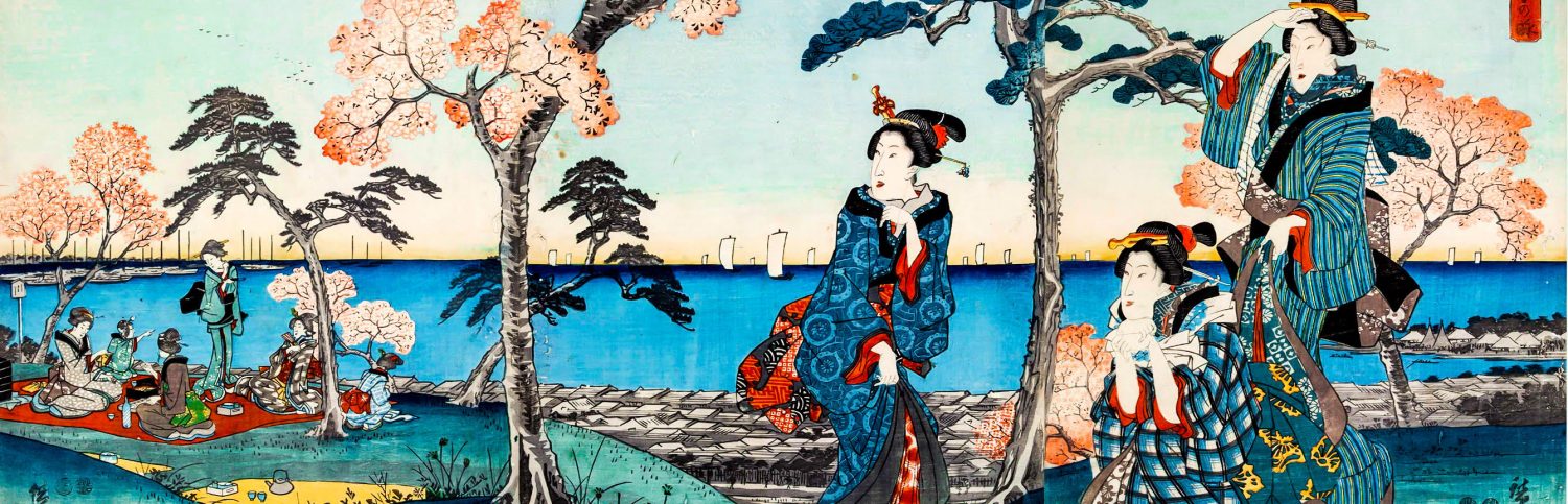
But until recently, the shrine was still located on the river. When the unsightly elevated highway that is 国道6号 Kokudō Roku-gō National Highway 6 was built in the 1960’s, the shrine was moved about 150 meters to the east, partly to protect the shrine from being so close to the river and mostly to make way for the highway. This highway expansion, like all of the other elevated highways in Tōkyō, became an instant eyesore and destroyed the scenery of this once historic area. This area was once so famous for its view of the river, of cherry blossoms, and of far off 筑波山 Tsukuba-san Mt. Tsukuba that even 歌川広重 Utagawa Hiroshige painted it. Judging from its former fame and from the splendid representation by Hiroshige, I think it’s a tragedy we lost this one. To what we’re left with is a fairly obscure – and fairly ugly – bridge and the shrine that started it all is just an afterthought of a bygone era living under a filthy, noisy highway.

Just a quick note, if I may. Part of what inspired me to right this article is an old post by blogger, Rurōsha, who is a lover of the Sumida River and of Tōkyō’s 下町 shitamachi low city. If you love Tōkyō’s rivers and shitamachi, you may like her blog. She gives a little more info about the shrine and her impressions of it.
Also, I visited the site the other day and took these pictures.
.
.
__________________________
[i] Here’s my article on the Arakawa.
[ii] Here’s my article on the Tone.
[iii] Yes, the kanji is “wrong” intentionally. More about that in my article on the Sumida River here.
[iv] Another, much more ridiculous legend, says the shrine was established by 日本武尊 Yamato Takeru no Mikoto Yamato Takeru, ie; Captain Japan. Long time readers should be able to guess my feelings on this theory.
[v] Keep in mind, this is a local tradition preserved by the shrine. There are no documents that verify Yoritomo’s visit.
[vi] Ukijima (or Ukishima) means something like “floating island.”
[vii] There are shrines called Suijinsha and Suijingū all over Japan.
[viii] Is it just me? Or does “Horny Boatmen” sound like a great band name? Somebody get on that stat!
[ix] There are traditions that say 源頼朝 Minamoto no Yoritomo and later 太田道灌 Ōta Dōkan had built bridges here but these fell into disrepair, once again giving rise to a ferryboat system. I can’t say if this was true or not.
[x] I’m assuming this was in reaction to a string of destructive earthquakes in Japan in the 70’s and 80’s. They were nothing as bad as the 1995 Kōbe Earthquake or cataclysmic 2011 Tōhoku Earfquake, but still there was a lot of damage done and a lot of people died.
[xi] Judging from the Hiroshige print, I’m guessing Sumidagawa Shrine had become a popular name for the shrine by the late Edo Period..

really interesting.
sad that this shrine isn’t beautiful anymore.
thanks!